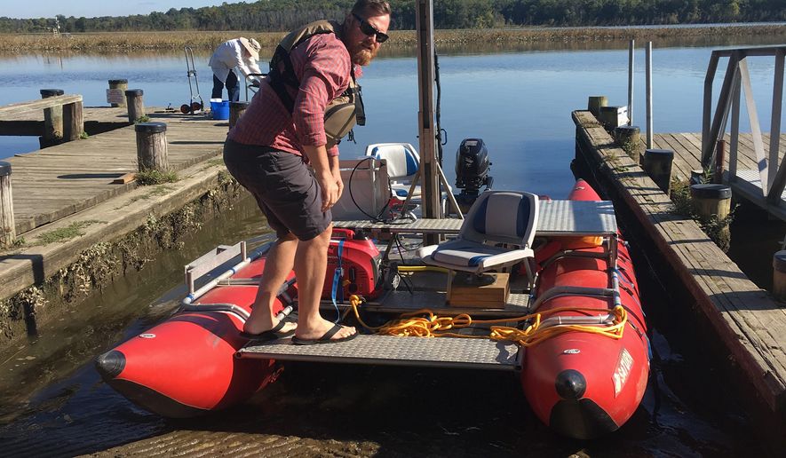
ON THE PATUXENT RIVER | First mapped by John Smith in 1608, Maryland’s serene Patuxent River now is being carefully photographed to create a virtual map that can be accessed via smartphones and computers.
Today’s high-tech mapping of the Patuxent is part of a project to create a virtual tour of the 3,000-mile Captain John Smith Chesapeake National Historical Trail, which the nonprofit Chesapeake Conservancy has undertaken with Ryan Abrahamsen of Terrain360.
“What we’re doing here is groundbreaking,” Mr. Abrahamsen said last week as he directed his custom-made pontoon raft down the river during a mapping expedition. “No one’s mapped waterways like we have.”
Since 2012 his company, Terrain360, has specialized in creating 360-degree views of trails and parks, and has produced virtual tours of nature attractions in California, Utah, Georgia, Maine, Pennsylvania, Virginia — and now Maryland.
To photograph and document the river, Mr. Abrahamsen has built a watercraft that supports a tower with six fisheye-lensed cameras. As he travels the length of the waterway, a computer program he has designed monitors and synchronizes the cameras when they take photos.
Users accessing Terrain360.com are treated to a virtual reality of some of the nature preserves around the country, “walking” a trail or “sailing” down a river by moving their mobile devices left or right. Desktop computers allow users to explore all aspects of the documented trails.
Jody Couser of the Annapolis-based Chesapeake Conservancy said that creating a vivid, easily accessed presentation of the Chesapeake Bay watershed is a key component of the group’s conservation efforts.
“A few years ago we started this project to try to connect people — at least virtually — to the Chesapeake Bay’s great rivers, because we know that you’re not going to help protect the Chesapeake and fight for it and try to restore the Chesapeake if you’re not familiar with it,” Ms. Couser said.
Terrain360’s views of the Patuxent are also available on the Chesapeake Conservancy’s web site.
“We thought of several ways to try and connect people at least virtually to these places. These virtual tours are one example, and another is our wildlife webcams, Ms. Couser said. “What we’re hoping is that will be maybe an entry point for people, but we definitely want them to come out and experience the real thing.”
The conservancy is conducting several projects that monitor and map key areas to sharpen understanding of conservation needs such as water quality, fish survey count, land use and conservation. Other programs to engage the public include the webcams that are placed in the nests of ospreys, great blue herons and peregrine falcons.
Of its virtual tours, one of the conservancy’s most frequently visited sites is Mallow’s Bay, famous for its “ghost ships” — a veritable graveyard of destroyed seacraft, many from World War I, that were built quickly and in excess, Ms. Couser said.
“When you build something quickly, they’re often not the best quality, so after the war they decided they no longer needed them. Back in those days, they discarded them in the Potomac River — which we would never do today, of course,” she said. “But over time, now the shipwrecks have become thriving ecological habitats.”
Ms. Couser and Mr. Abrahamsen said the virtual tours are useful tools for people to research or plan a visit.
Stretching some 115 miles from the Piedmont region to the bay, the Patuxent is the longest river completely within Maryland’s borders. It separates Montgomery, Prince George’s, Charles and St. Mary’s counties on its west side from Howard, Anne Arundel and Calvert counties on its east.
John Smith, who helped settle Jamestown, Virginia, explored part of the Patuxent and the Chesapeake with the aid of American Indians, and created maps that were used by travelers and traders for hundreds of years.
• Laura Kelly can be reached at lkelly@washingtontimes.com.


Please read our comment policy before commenting.